| Name | Location | Description |
| Cultural Landscape of Hawraman/Uramanat | Kurdistan Province | The remote and rugged environment of the region, which has been inhabited by the Hawrami people, an agropastoral Kurdish tribe, dates back to around 3000 BCE. The property is divided into two parts: The Central-Eastern and the Western Valley. It is situated in the Iranian provinces of Kurdistan and Kermanshah near the country’s western border (Lahun, in Kermanshah Province). Over millennia, human settlement in these two valleys has evolved to fit the challenging alpine environment. |
| Gonbad-e Qābus | Golestan Province | A testament to the cultural contact between Central Asian nomads and the ancient Iranian civilization is the 53 m-high mausoleum that was constructed in 1006 for Qbus ibn Voshmgir, a Ziyarid monarch and literati, close to the remains of the ancient city of Jorjan in north-east Iran. The tower is all that is left of Jorjan, a great epicenter of the arts and sciences that was devastated in the 14th and 15th centuries by the Mongol invasion. It is a superb and highly advanced illustration of Islamic architecture that had an impact on the construction of temples in Iran, Anatolia, and Central Asia. This is easily one of the best UNESCO sites in Iran (Gonbad-e-Qābus). |
| Lut Desert | Kerman and Sistan and Baluchestan Provinces | In the southeast of the nation is where you’ll find Dasht-e-Lut, also known as the Lut Desert. Strong winds sweep through this dry subtropical region between June and October, carrying silt and causing massive aeolian erosion. As a result, the location offers some of the most impressive examples of aeolian yardang landforms (massive corrugated ridges). Additionally, there are significant rocky deserts and dune areas there. The property serves as an outstanding illustration of current geological processes. |
| Sassanid Archaeological Landscape in the Fars Region | Fars Province | The three geographical regions of Bishapur, Firuzabad, and Sarvestan, in the southeast of Fars Province, are home to eight archaeological sites. The Sassanian Empire, which ruled over the area from 224 to 658 CE, left behind fortified buildings, palaces, and city layouts that may be found today. A city and architectural structures from Shapur I’s successor, Ardashir Papakan, as well as the capital established by the dynasty’s founder, Ardashir Papakan, are all included in this list of locations. |
| Caspian Hyrcanian mixed forest | Golestan Province | A distinctive wooded massif made up of Hyrcanian forests runs 850 km along the southern Caspian Sea coast. Twenty Persian leopards are said to live in Golestan National Park, one of the most crucial sites in the world for the endangered species. The natural ungulates of the forest, including wild goats, roe deer, and wild pigs, are a source of food for these famed predators. The forests are teeming with unusual fauna, including the endemic Steiner’s Lacerta, cave salamander, and Hirkan field mouse. Examples of post-glacial relict trees are Caucasian zelkova and Caucasian wingnut. Although glaciations eliminated these species from the majority of their previous habitats, these woods provided a haven where tiny populations have endured to this day. |
| Pasargadae | Fars Province | Cyrus II the Great established Pasargadae, the first dynasty capital of the Achaemenid Empire, on Pars, the Persians’ ancestral home, in the sixth century BC. The Mausoleum of Cyrus II, Tall-e Takht, a fortified terrace, and a royal ensemble with a residential palace, lovely gatehouse, audience hall, and gardens are three extremely significant relics in the 160-ha complex. The first significant multicultural empire in Western Asia had its capital at Pasargadae. It is regarded as the first empire to appreciate the cultural variety of its various peoples, spanning the Eastern Mediterranean, Egypt, and the Hindus River. This was reflected in Achaemenid architecture, which was a synthesis of several civilizations. |
| Persepolis | Fars Province | Persepolis, which Darius I built in 518 B.C., served as the seat of the Achaemenid Empire. |
| Shahr-i Sokhta | Sistan and Baluchestan Province | A place called Shahr-i Sokhta, which means “Burnt City,” is where old trade routes that cross the Iranian plateau converge. Ruins of the mudbrick city depict the earliest advanced cultures in eastern Iran. It was founded circa 3200 BC and inhabited for four major eras up to 1800 BC, during which time the city’s several different neighborhoods grew. |
| Shushtar Historical Hydraulic System | Khuzestan Province | Darius the Great, who reigned in the fifth century B.C., is credited with creating the Shushtar, Historical Hydraulic System, which has been recognized as a marvel of artistic brilliance. Two substantial canals had to be built in order to divert water from the Kârun River; one of them, the Gargar Canal, is still operational today and provides water to the city of Shushtar via a network of tunnels that feed mills. It creates a stunning cliff from which water flows into a pool down below. After there, it enters the plain to the south of the city, where it has made it possible to cultivate 40,000 acres of orchards and farmland called Mianâb (Paradise). This has been confidently included on the list of the top UNESCO sites in Iran. |
| Susa | Khuzestan Province | The property, which is located in the lower Zagros Mountains of southwest Iran, comprises Ardeshir’s palace on the opposite bank of the Shavur River and a number of archaeological mounds rising on the eastern side of the river. Administrative, residential, and palace buildings are among the architectural monuments that have been unearthed. Susa is made up of many tiers of layered urban settlements that date from the late fifth millennium BCE to the thirteenth century CE. The area is a great example of the Parthian, Persian, and Elamite cultural traditions that were once prevalent. |
| Takht-e Soleyman | West Azerbaijan Province | In the volcanic mountain range of northwest Iran, a valley contains the Takht-e Soleyman ancient site. The site has the primary Zoroastrian shrine as well as a Sasanian temple dedicated to Anahita that was largely rebuilt during the Ilkhanid (Mongol) era (13th century). Islamic architecture changed significantly as a result of the layout, palace, and fire temple designs. |
| Tchogha Zanbil | Khuzestan Province | The sacred city of the Kingdom of Elam’s ruins, which are ringed by three gigantic concentric walls, is located near Tchogha Zanbil. The thousands of worthless bricks left behind following Ashurbanipal’s siege on the city, which was built around 1250 B.C., show that it was abandoned unfinished. This is one of Iran’s historical places that needs to be visited. |
| The Persian Garden | Many Provinces (Fars, Kerman, Razavi Khorasan, Yazd, Mazandaran, and Isfahan Provinces) | The property consists of nine gardens in nine different provinces. They provide an illustration of the range of Persian garden designs that have evolved and adapted to meet varied climatic conditions while maintaining essential concepts that date back to the time of Cyrus the Great’s rule in the sixth century BC. The four Zoroastrian elements—heaven, earth, water, and plants—as well as Eden was intended to be represented in the Persian garden. Water was used extensively for irrigation and decoration in the four distinct areas that made up the Persian garden. These gardens, which date back to the sixth century BC, feature structures like cottages, walls, and pavilions in addition to complex irrigation systems. |
| Trans-Iranian Railway | Mazandaran, Tehran, and Khuzestan Provinces | The Trans-Iranian Railway connects the Persian Gulf in the southwest with the Caspian Sea in the northeast, through four different climatic areas, two mountain ranges, hills, rivers, plains, and hills. The 1,394-kilometer-long railway was successfully designed and constructed during the course of a 1927–1938 cooperation between the Iranian government and 43 construction firms from various countries. The railway is well-known for both its size and the technical prowess required to navigate barriers including steep terrain and other difficulties. |
| Persian Qanat | Razavi Khorasan, South Khorasan, Yazd, Kerman, Markazi and Isfahan Provinces | The archaic qanat system, which includes extracting water from alluvial aquifers at valley crests and transferring it via underground tubes by gravity for lengths that can be many kilometers, supplies agriculture and permanent communities throughout Iran’s dry regions. The eleven qanats of this system have watermills, staff rest areas, and water reservoirs. The ancient communal management system that is still in operation allows for the equitable and sustainable sharing and distribution of water. The qanats offer excellent evidence of cultural practices and civilizations in dry, arid regions. It is among Iran’s most exquisite historical sites. |
The Persian Garden
Nine gardens in as many provinces are part of the property of UNESCO sites in Iran. They serve as an example of the variety of Persian garden designs that have developed and changed to accommodate various climatic conditions while preserving fundamental ideas that date back to Cyrus the Great’s reign in the sixth century BC. The Persian garden was designed to represent Eden and the four Zoroastrian elements of heaven, water, earth, and plants. The Persian garden was always split into four sections, with water playing a significant role in both irrigation and adornment. These gardens, which have been around since the 6th century BC, have structures like pavilions, walls, and houses in addition to complex irrigation systems. They have had an impact on landscape design in places like Spain and India.
Persepolis
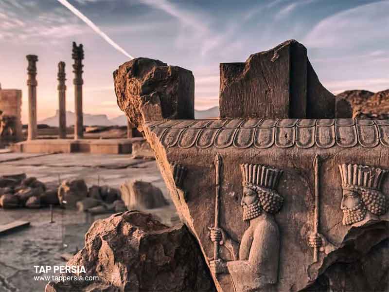
One of the most important ancient sites in the world is Persepolis, whose spectacular remains are located in southwest Iran at the base of Kuh-e Rahmat (Mountain of Mercy). This is one of the top UNESCO sites in Iran. The royal city of Persepolis is regarded as the pinnacle of Achaemenid (Persian) grandeur in the areas of architecture, urban planning, building technology, and art. It is also one of the archaeological monuments that bear unique witness to a very old civilization and has no comparable. King of the Achaemenid Empire Darius the Great began construction on the vast terrace of the city in 518 BCE. Successive monarchs constructed a series of magnificent palatial structures on this terrace, including the enormous Apadana palace and the Throne Hall (also known as the “Hundred-Column Hall”).
Caspian Hyrcanian Mixed Forest
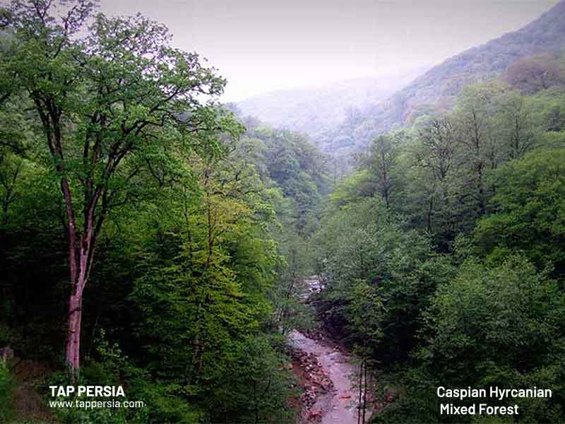
The Caspian Hyrcanian Mixed Forest is included in the list of UNESCO sites in Iran. A distinctive wooded massif made up of Hyrcanian trees runs 850 km along the southern Caspian Sea coast. These broad-leaved woods have existed for between 25 and 50 million years when they dominated this Northern Temperate zone. During the Quaternary glaciations, these old forest regions shrank and then grew once again when the temperature warmed. Their floral variety is astounding: barely 7% of the nation, or the Hyrcanian area, has 44% of the known vascular plants in Iran. 180 species of birds typical of broad-leaved temperate woods and 58 animal species, including the fabled Persian Leopard, have so far been identified.
Pasargadae
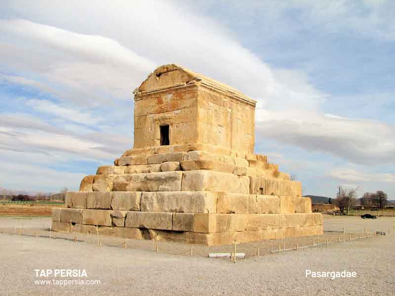
This is one of the famous and popular UNESCO sites in Iran. The archeological ruins of the first Persian Empire capital, which date to the sixth century BC, are located near Pasargadae. The tomb of Cyrus the Great, who established the Achaemenid Empire and later conquered most of the ancient Near East, Southwest Asia, Central Asia, and the Caucasus, is the most significant monument in the region.
The fourfold garden style known as the Persian Chahar Bagh is first seen in Pasargadae’s gardens. The complex also includes palaces, castle ruins, and a 14-meter-tall stone tower, together known as “the royal ensemble.”
Trans-Iranian Railway
The Trans-Iranian Railway runs across two mountain ranges, rivers, hills, forests, and plains, as well as four distinct climatic regions, to connect the Persian Gulf in the southwest with the Caspian Sea in the northeast. The 1,394-kilometer-long railway was successfully conceived and built in a partnership between the Iranian government and 43 construction companies from other nations that began in 1927 and ended in 1938.
The railway is one of the best UNESCO sites in Iran and is renowned for its size and the technical feats needed to get around obstacles like steep terrain and other challenges. Its construction required substantial mountain cutting in some places, while the difficult terrain in others required the building of 224 tunnels, 11 spiral tunnels, 174 big bridges, and 186 minor bridges. The Trans-Iranian Railway was built using national taxes rather than foreign investment or control, unlike other early railroad projects.
Susa
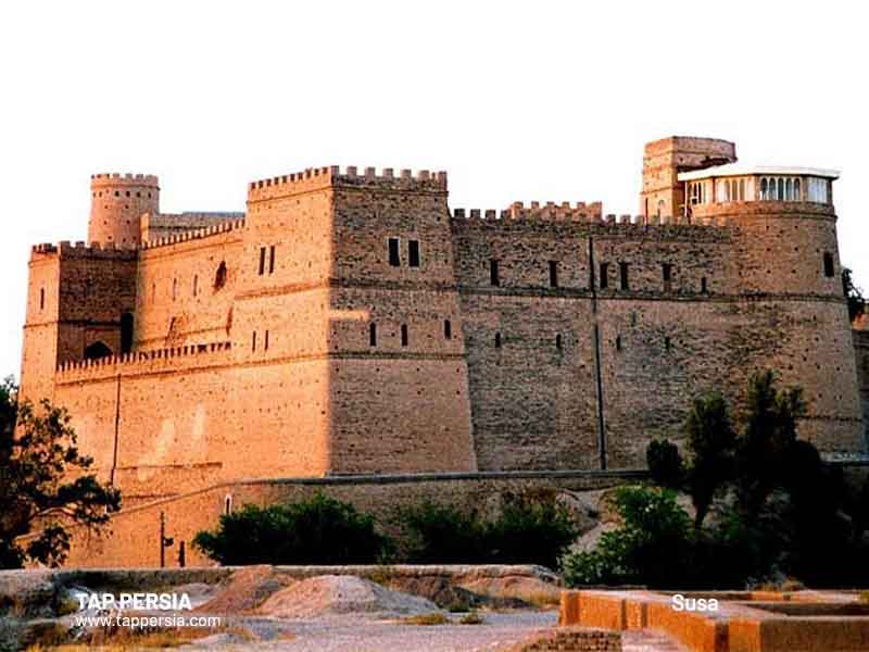
The property, which is situated in the lower Zagros Mountains in Iran’s southwest, includes Ardeshir’s palace on the opposite bank of the Shavur River as well as a number of archaeological mounds rising on the eastern side of the river. Administrative, residential, and palace buildings are among the architectural monuments that have been unearthed. From the late 5th millennium BCE until the 13th century CE, Susa comprises many levels of overlaid urban communities. The location provides an excellent testament to the long-gone Elamite, Persian, and Parthian cultural traditions. This property is proudly introduced on the list of UNESCO sites in Iran.
The Persian Qanat
On the list of our UNESCO sites in Iran is the Persian Qanats. Agriculture and permanent settlements are supplied across Iran’s arid areas by the antiquated qanat system, which involves drawing water from alluvial aquifers at valley heads and moving it via subterranean tubes by gravity for distances that can be many kilometers. This system’s eleven qanats feature watermills, worker rest spaces, and water storage facilities. Water may be shared and distributed in an equitable and sustainable manner thanks to the traditional communal management system that is still in use. The qanats offer extraordinary evidence of cultural practices and civilizations in dry, desert regions.
Shahr-i Sokhta
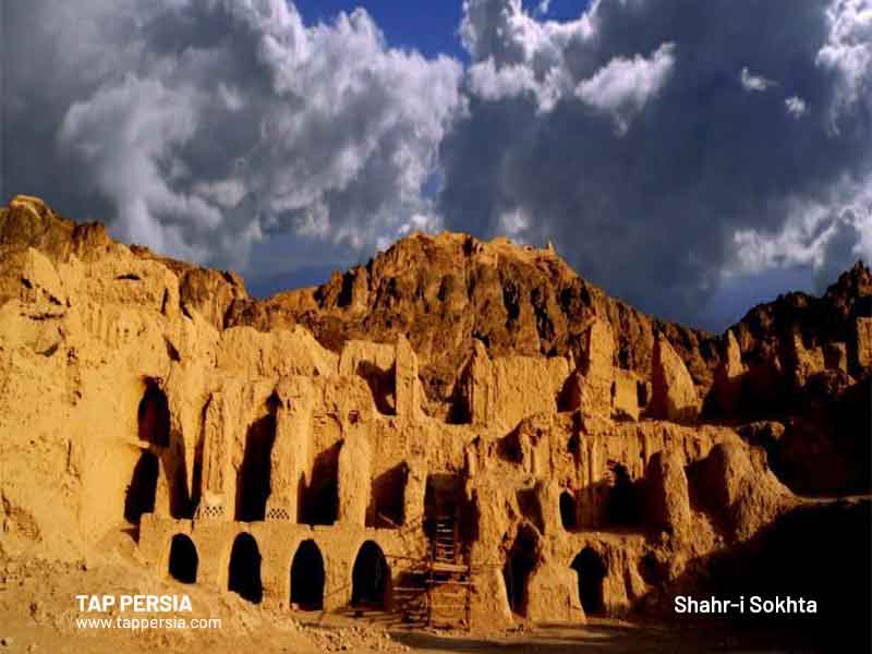
Shahr-i Sokhta, which translates to “Burnt City,” is situated where ancient trade routes that span the Iranian plateau meet. The mudbrick city’s ruins reflect the beginning of eastern Iran’s earliest sophisticated societies. It was first settled in approximately 3200 BC, and from then until 1800 BC, it was inhabited during four major eras. During this time, the city developed various unique districts, including those where monuments were created and separate quarters for residence, burial, and manufacturing.
The city was eventually abandoned in the early second millennium due to changes in water routes and climate. This UNESCO site in Iran is a valuable resource for learning about the emergence of complex societies and interactions between them in the third millennium BC because of the buildings, burial grounds, and numerous important artifacts that have been discovered there and their well-preserved state as a result of the dry desert climate.
Lut Desert
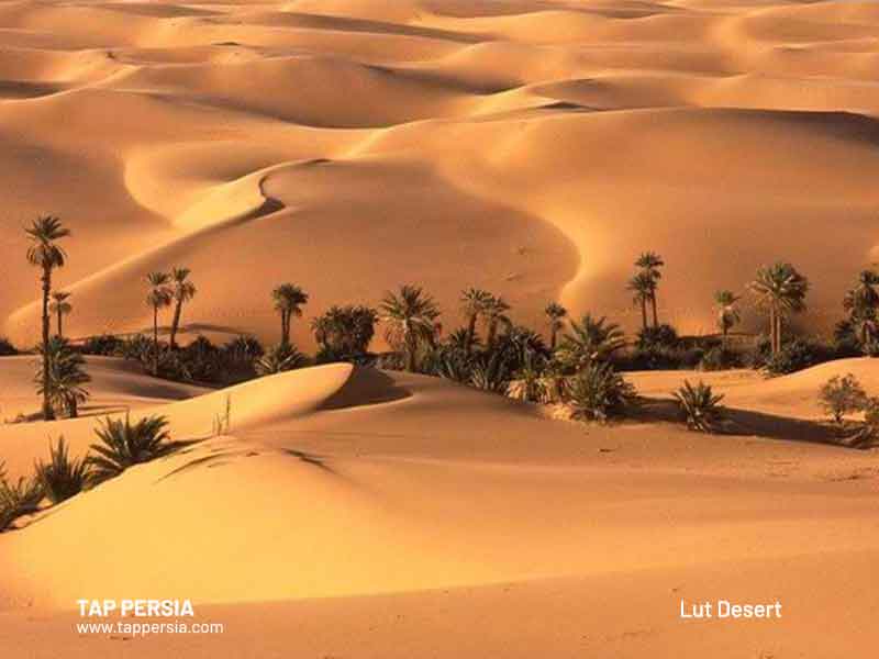
The Lut Desert is also one of Iran’s top UNESCO sites. Due to its natural desert phenomena, the Lut Desert and its surrounds exhibit a vast natural environment with potential and realized values: Kaluts landforms with the highest observed Yardangs anywhere on the planet (bedrock features carved and streamlined by sandblasting), the highest sandy dunes, and Nebkha dune fields (the phenomenon of interaction between wind erosion and vegetation resulted in a sandy dune formed around the plants), massive erosional ditches, historical areas and villages, rare salt phenomena and extensive stony desert pavements (Hamada), tectonic holes, Hydrologic networks, Qanats, and ancient civilization settlements.
The Hawraman/Uramanat Cultural Landscape
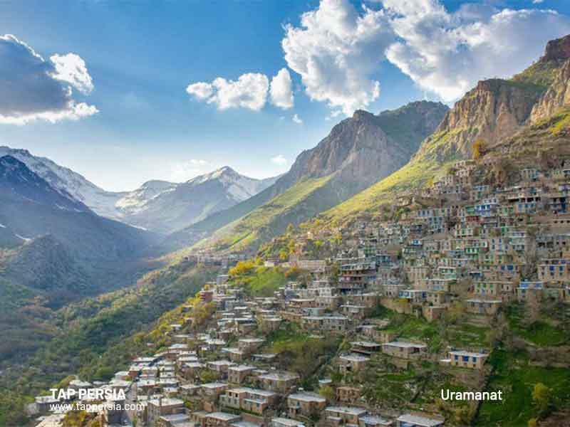
Another one of the top UNESCO sites in Iran is the Hawraman/Uramanat Cultural Landscape. In these two valleys, human settlement has evolved over millennia to fit the challenging alpine environment. The Hawrami people, who are semi-nomadic and inhabit the lowlands and highlands at various times of the year, are known for their tier-based steep-slope design and construction, dry-stone terrace gardening, livestock raising, and seasonal vertical movement.
The Kurdistan and Kermanshah provinces share ownership of the Hawraman/Uramanat cultural landscape site, which is situated on the slopes of Sarvabad county. The rural region of the villages is distinctive in that it has several dense, stepped rows of buildings, with the uppermost row’s yard formed by the roofs of the lower ones. The Hawrami people are an agropastoral Kurdish group that has lived in the area since about 3000 BCE, and their traditional culture is evident in the area’s isolated and hilly geography.
How Many UNESCO Sites Are in Iran?
56 properties from Iran are listed tentatively by UNESCO.
Which is the First UNESCO Heritage Site of Iran?
One of the first Iranian sites to be listed with UNESCO in 1979 was Meidan Emam in Isfahan. Shah Abbas constructed this area in the 17th century. You need to check out this beautiful UNESCO site in Iran.
Which Country Has the Most UNESCO Sites?
The majority of the world’s UNESCO World Heritage Sites are located in Italy. The nation currently has 58 world historic sites according to the UNESCO committee’s yearly designation of additional listings.
What is an Example of a UNESCO Site in Iran?
Zanbil Tchogha. the many ancient and worthy bricks Ashurbanipal’s siege of the city, which was constructed in 1250 B.C., left behind is one of the best UNESCO sites in Iran.
Does Iran Have Any World Heritage Sites?
One of the ten nations with the most cultural heritage sites on UNESCO’s World Heritage list is Iran, which has 24 UNESCO World Heritage Sites.